- الصفحة الرئيسية /
- المطبخ والمنزل /
- Wall Art /
- Posters & Prints /
- شوشونال جيافرك: الهند المبطن كلكيا - 23.5 × 30.25 بوا -...
0 ratings


منتج #:
44577084
شوشونال جيافرك: الهند المبطن كلكيا - 23.5 × 30.25 بوا - قماش
منتج #:
44577084
BHD 51
Price Details
Excluding Shipping & Custom charges ( Shipping and custom charges will be calculated on checkout )
*All items will import from أمريكا
0 ratings
اكتب رأيك
متوفر فى المخزون
كمية:
اطلب الآن واحصل عليه حول الخميس, يوليو 23
معاملة آمنة
تعمل يوباي جاهدة لحماية أمنك وخصوصيتك. يضمن نظام أمان الدفع المتقدم لدينا السرية من خلال تشفير معلوماتك أثناء النقل باستخدام بروتوكولات AES (معايير التشفير المتقدمة) وSSL (طبقة المنافذ الآمنة). تفاصيل الدفع الخاصة بك آمنة بنسبة %100 لأننا لا نشارك تفاصيل الدفع الخاصة بك مع بائعين تابعين لجهات خارجية
أفضل شركائنا اللوجستيين

خرائط National Geographic هي المعيار الذي يتم قياس الآخرين مقابله.
شحن
سريع
استرجاع
مجاني*
تغليف أمن
منتجات أصلية %100
PCI DSS Compliance

ISO 27001 Certified
Note: Step Down Voltage Transformer required for using electronics products of أمريكا store (110-120). Recommended power converters اشتري الآن.


مايفيد
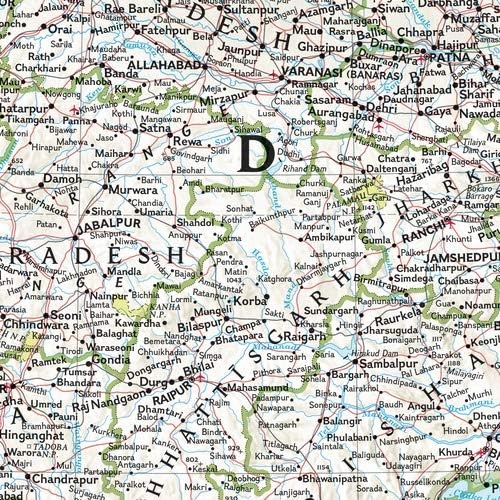
رسم الخرائط التفصيلية
تعرض خريطة الحائط هذه تفاصيل جغرافية معقدة، مما يجعلها أداة تعليمية مثالية للمتعلمين وقطعة زخرفية للمتحمسين الذين يقدرون المناظر الطبيعية المتنوعة في الهند.
مواد قماشية عالية الجودة
هذه الخريطة مطبوعة على قماش مدلفن متين، تقاوم التآكل مع إضافة لمسة أنيقة إلى أي مساحة، مما يعزز الجماليات وطول العمر مقارنة بالخرائط الورقية.
تنسيق كبير
تبلغ أبعاد هذه الخريطة كبيرة الحجم 23.5 × 30.25 بوصة، وتوفر رؤية واسعة وسهولة القراءة، وهي مثالية للفصول الدراسية أو المكاتب أو المساحات الشخصية، مما يسمح بتجربة غامرة لجغرافيا الهند.
تفاصيل المنتج
- بناء الوعي العالمي: مثالي للفصل الدراسي! هذه الخريطة هي الأداة المثالية لمساعدة الطلاب على تصور العالم جغرافيًا حقًا.
- خريطة كلاسيكية للمكتب أو المنزل: الحجم المثالي لمجموعة حائط المعرض - ستضيف الألوان الغنية موسيقى البوب إلى أي جدار!
- CANVAS: مطبوعة على قماش لعرض فني عالي الجودة. يجعل لمنتج جميل على منزلك أو مدرستك أو جدار مكتبك.
- جاهز للإطار: مع قماش احتياطي 5 بوصة على كل جانب ، تكون الخريطة جاهزة للتمدد على إطار من القماش.
- رسم تخطيطي: خرائط National Geographic هي المعيار الذي يتم قياس الآخرين مقابله. يمكنك الاعتماد على هذا المنتج الذي يحتوي على أعلى جودة من المحتوى والعرض في الصناعة.
| اسم العلامة التجارية | الجغرافيا الوطنية |
| نوع الخريطة | المادية والسياسية |
| UPC | 749717046023 |
| الصانع | MapSherpa |
| حجم الورق | 23.5 × 30.25 بوصة (59.7 سم) |
| أبعاد البند L x W | 23.5 "L x 30.25" W (59.7 سم) |
| العلامة التجارية | National-Geographic |
| حجم الورقة | 23.5 × 30.25 بوصة (59.7 سم) |
| أبعاد المنتج ( L x W x H ) | 23.5 "L x 30.25" W (59.7 سم) |
من يجب أن يشتري؟

-
المعلمين
مثالي للمعلمين الذين يرغبون في تحسين دروس الجغرافيا بصريًا وتعزيز فهم أفضل لتضاريس الهند.
-
عشاق السفر
مثالية للأفراد الذين يخططون لرحلات إلى الهند، مما يوفر رؤى مفصلة حول المناطق والثقافة والجغرافيا في البلاد.
-
ديكور المنزل
كبيرة لأولئك الذين يتطلعون إلى إضافة عنصر تعليمي بعد أنيق إلى مكتبهم المنزلي أو مساحة المعيشة.

-
المستخدمين العاديين
أقل ملاءمة لأولئك الذين يحتاجون فقط إلى معلومات الخريطة الأساسية أو المراجع العرضية عند مناقشة الهند.
-
المغامرون في الهواء الطلق
ليست مثالية للمتنزهين أو المعسكرين الذين يحتاجون إلى خريطة متينة ومقاومة للطقس للملاحة العملية في البرية.
-
المتسوقون ذوو الميزانية المحدودة
قد يكون مكلفًا للغاية بالنسبة للأفراد الذين يبحثون عن خيار ميسور التكلفة مع ميزات ومواصفات الخريطة الأساسية.
وصف المنتج
About This Item
Introducing the National Geographic: India Classic Wall Map - a must-have for geography enthusiasts, educators, and anyone interested in discovering the beauty of India. This stunning map showcases India's political and physical features with unrivaled detail and accuracy. The state-of-the-art cartographic techniques used in its creation ensure exceptional quality, making it a valuable resource for classrooms and teaching environments. With its engaging design and user-friendly layout, this map allows for easy navigation and understanding of India's geography.
Students can develop their navigation skills using latitude and longitude, as well as explore political boundaries within the country. Featuring a bright and easy-to-read color palette, including blue oceans and stunning shaded relief, this map embodies the classic National Geographic aesthetic that has been trusted by educators for over 75 years. The Transverse Mercator projection enhances its navigational capabilities, making it ideal for regions near the equator. The names of political and geographic features are carefully placed to maintain legibility. With meticulous research and adherence to National Geographic's convention of independent, apolitical decisions based on extensive research from multiple authoritative sources, this map sets the standard for reference maps. Printed on high-quality canvas, this map not only provides accurate information but also showcases the artistic quality of National Geographic's iconic wall maps.
Additionally, five inches of additional material on each side ensure that you have enough material to stretch the map on a frame without compromising its integrity. To safeguard this valuable piece of cartography during shipment, your map will be rolled and packaged in a sturdy tube. Rest assured that it will arrive in pristine condition, ready to adorn your wall and inspire exploration. Experience the beauty and educational value of the National Geographic: India Classic Wall Map. Whether you're a teacher, student, or simply an admirer of India's rich geography, this map is an essential addition to your collection.
Explore the wonders of India and embark on a journey of discovery today.
هل لديك أي استفسار؟ تحدث معنا
أسئلة وأجوبة العملاء
-
سؤال:
ما هي أبعاد ناشيونال جيوغرافيك: خريطة حائط البحرين الكلاسيكية؟
إجابه: The National Geographic: Bahrain Classic Wall Map measures 23.5 x 30.25 inches. This size makes it an ideal choice for wall display, providing a clear and comprehensive view of Bahrain's geographical features, major cities, and significant landmarks. Its larger format allows for more detailed illustrations and easy readability, making it perfect for educational use in classrooms or as a decorative piece in homes. Whether you're a geography enthusiast or simply looking to beautify your space, this map serves both functional and aesthetic purposes. -
سؤال:
What material is the National Geographic Bahrain Wall Map made of?
إجابه: The National Geographic Bahrain Classic Wall Map is made of high-quality rolled canvas. This material ensures durability and a premium look, making it resistant to wear and tear over time. Canvas also allows for vibrant color reproduction, ensuring that geographic details are clearly visible and attractive. Its rolled form simplifies storage and transportation, making it easy to handle. Perfect for anyone wanting a long-lasting, visually appealing map that can be showcased in various settings, including homes, offices, or educational spaces. -
سؤال:
هل يمكن تأطير هذه الخريطة بسهولة؟
إجابه: Yes, the National Geographic: Bahrain Classic Wall Map can be easily framed. Its dimensions of 23.5 x 30.25 inches fit standard-sized frames, which makes finding an appropriate frame convenient. Framing the map not only enhances its visual appeal but also protects it from dust and damage. Many customers opt for a frame to display it in their living rooms or offices, creating a focal point that sparks conversation and provides a stylish way to showcase their interest in geography. -
سؤال:
هل هذه الخريطة مناسبة للأغراض التعليمية?
إجابه: Absolutely! The National Geographic: Bahrain Classic Wall Map is ideal for educational purposes. Its detailed geographical representation includes significant cities, rivers, mountains, and borders, making it a helpful tool for students and educators alike. Teachers often use this map to facilitate lessons on geography, culture, and history. Additionally, it's great for interactive learning, where students can locate states or cities, making geography engaging and informative in classrooms. -
سؤال:
هل ستتلاشى هذه الخريطة بمرور الوقت إذا تم عرضها في ضوء الشمس؟
إجابه: While the National Geographic: Bahrain Classic Wall Map is printed on durable rolled canvas, like any print, it may be susceptible to fading if exposed to direct sunlight over prolonged periods. To preserve its vibrant colors and longevity, it is recommended to hang it in a location that receives indirect light or to use UV-protected glass if framed. Many users choose to display it in offices or study rooms where the light is controlled, ensuring the map retains its stunning visual for years. -
سؤال:
What locations are highlighted on the National Geographic Bahrain Wall Map?
إجابه: The National Geographic: Bahrain Classic Wall Map highlights a comprehensive array of geographical features, including major cities, rivers, mountain ranges, and state boundaries. Key locations like Delhi, Mumbai, Kolkata, and Bangalore are prominently marked alongside important national parks and landmarks. This makes it not only a functional tool for understanding the layout of Bahrain but also an insightful reference for those interested in traveling or learning more about the rich diversity and culture of Bahrain. It's often used in travel planning to identify destinations. -
سؤال:
هل هذه الخريطة مقاومة للماء أم مقاومة للماء؟
إجابه: The National Geographic: Bahrain Classic Wall Map, while printed on canvas, is not waterproof or water-resistant. It is designed primarily for display purposes. Therefore, it is advisable to keep it away from moisture or damp areas. Users may opt to laminate it or use a protective spray if they intend to have it in a more exposed environment. Many customers find it makes a great addition to living rooms, offices, or schools, as long as it's displayed in a suitable, dry location. -
سؤال:
How can I clean the National Geographic Bahrain Wall Map without damage?
إجابه: To clean the National Geographic: Bahrain Classic Wall Map without causing damage, use a soft, dry cloth to gently dust off any particles. For more stubborn stains, lightly dampen the cloth with water to avoid soaking the canvas. It’s crucial to avoid using harsh chemicals or scrubbing, as these could damage the print. Maintaining the map's cleanliness enhances its aesthetic and longevity, making it an enchanting addition to any wall display, whether in personal collections or educational settings. -
سؤال:
هل يمكنني شراء هذه الخريطة عبر الإنترنت؟
إجابه: Yes, you can purchase the National Geographic: Bahrain Classic Wall Map online. It is available at various e-commerce platforms. In Bahrain, you can conveniently buy this map from Ubuy, which offers a simple shopping experience along with fast delivery options. Whether you’re looking to enhance your home decor or need a functional map for educational purposes, Ubuy provides easy access to this classic wall map. -
سؤال:
ما هي المواضيع أو الأنماط التي تصورها الخريطة؟
إجابه: The National Geographic: Bahrain Classic Wall Map depicts a traditional yet visually appealing style, characterized by its vibrant colors and detailed geographical features. The map showcases various themes such as political boundaries, significant cities, and physical landscapes like mountains and rivers. This classic design makes it an excellent choice for those who appreciate not only functionality but also artistry in cartography. Perfect for both educational environments and home décor, it adds a touch of sophistication to any space while serving as an informative reference.
NationalGeographic Posters & Prints مراجعة تحريرية
خريطة National Geographic India Classic Wall هي خريطة مفصلة بشكل جميل تأتي على قماش. تتميز الخريطة بتضاريس دقيقة وطرق رئيسية ومعالم. الألوان نابضة بالحياة وسهلة القراءة ، مما يجعلها إضافة رائعة لأي منزل أو مكتب. تضمن مادة القماش المتانة والتعليق السهل. أشاد العملاء بدقة الخريطة وأعجبوا بمستوى التفاصيل. وقد استخدمها البعض كأداة تعليمية للجغرافيا والتاريخ. كما تم استقبال المواد القماشية بشكل جيد بسبب متانتها. بشكل عام ، تعد National Geographic India Classic Wall Map منتجًا عالي الجودة واستثمارًا رائعًا لأي شخص مهتم بالجغرافيا أو يتطلع إلى إضافة لمسة زخرفية إلى مساحته.
مراجعات العملاء وتقييماتهم
1 تقييمات العملاء
-
5 نجمة
100%
-
4 نجمة
0%
-
3 نجمة
0%
-
2 نجمة
0%
-
1 نجمة
0%
أضف تقييم لهذا المنتج
شارك أفكارك مع عملاء آخرين
إيجابيات
- تضاريس ومعالم دقيقة
- ألوان نابضة بالحياة وسهلة القراءة
- مادة قماشية متينة
- رائعة للتعلم والديكور
تاريخ سعر المنتج
معلومات مهمة
- القيود: بالنسبة للمنتجات التي يتم شحنها دولياً، يُرجى ملاحظة أن أي ضمان من الشركة المصنعة قد لا يكون صالحاً؛ قد لا تتوفر خيارات خدمة الشركة المصنعة؛ قد لا تكون أدلة المنتج والتعليمات وتحذيرات السلامة مكتوبة بلغة بلد المقصد؛ قد لا يتم تصميم المنتجات (والمواد المصاحبة لها) وفقاً لمعايير بلد الوجهة والمواصفات ومتطلبات الملصقات؛ وقد لا تتوافق المنتجات مع الجهد الكهربي المستخدم في بلد الوجهة والمعايير الكهربائية الأخرى (تتطلب استخدام محوّل كهربي أو جهاز تحويل إذا كان ذلك مناسباً). المستلم مسؤول عن ضمان إمكانية استيراد المنتج بشكل قانوني إلى بلد الوجهة. عند الطلب من يوباي أو الشركات التابعة لها، يكون المستلم هو المستورد المسجل ويجب أن يلتزم بجميع القوانين واللوائح الخاصة ببلد الوجهة.
- ليست كل المنتجات المدرجة على يوباي معروضة للبيع، لأن يوباي هو محرك بحث عالمي. المنتجات تخضع للوائح التصدير / التجارة.
BHD 51
اطلب الآن واحصل عليه حول الخميس, يوليو 23
هذا المنتج غير ممنوع في بلدي. (الرجاء الضغط على الرابط أعلاه إذا لم يكن هذا المنتج ممنوعاً في بلدك ، لذلك سيقوم فريقنا بمراجعته والسماح به.)
كمية:
معاملة آمنة
تعمل يوباي جاهدة لحماية أمنك وخصوصيتك. يضمن نظام أمان الدفع المتقدم لدينا السرية من خلال تشفير معلوماتك أثناء النقل باستخدام بروتوكولات AES (معايير التشفير المتقدمة) وSSL (طبقة المنافذ الآمنة). تفاصيل الدفع الخاصة بك آمنة بنسبة %100 لأننا لا نشارك تفاصيل الدفع الخاصة بك مع بائعين تابعين لجهات خارجية
أفضل شركائنا اللوجستيين
أسرع توصيل عبر الحدود
المميزات والفوائد
- خريطة الهند الكلاسيكية تعرض البلاد بتفاصيل مذهلة.
- مثالية للفصول الدراسية مع التركيز على تدريس الجغرافيا أو الموضوعات البيئية.
- مثالية لمساعدة الطلاب على تطوير مهارات التنقل باستخدام خطوط الطول والعرض والحدود السياسية.
- مطبوعة على قماش عالي الجودة للعرض الفني في المنازل أو المدارس أو المكاتب.
- يتضمن 5 بوصات من المواد الإضافية على كل جانب لتمديد الخريطة على إطار.
- تلتزم الخرائط الجغرافية الوطنية بأعلى معايير الجودة والدقة.