- الصفحة الرئيسية /
- الكتب /
- كتب تعليمية /
- كتب المدرسة والتدريس /
- Instruction Methods /
- Social Studies /
- Mapping the World with Art Paperback – Januar...
0 ratings


منتج #:
1690130
Mapping the World with Art Paperback – January 2, 2013
96% من المشترين سيوصون بهذا المنتج لصديق
منتج #:
1690130
BHD 17
تفاصيل السعر
باستثناء رسوم الشحن والجمارك ( سيتم احتساب رسوم الشحن والجمارك عند إتمام الشراء )
*سيتم استيراد جميع العناصر من أمريكا
0 ratings
اكتب رأيك
متوفر فى المخزون
 مستورد من متجر USA
كمية:
اطلب الآن واحصل عليه حول الثلاثاء, سبتمبر 22
معاملة آمنة
تعمل يوباي جاهدة لحماية أمنك وخصوصيتك. يضمن نظام أمان الدفع المتقدم لدينا السرية من خلال تشفير معلوماتك أثناء النقل باستخدام بروتوكولات AES (معايير التشفير المتقدمة) وSSL (طبقة المنافذ الآمنة). تفاصيل الدفع الخاصة بك آمنة بنسبة %100 لأننا لا نشارك تفاصيل الدفع الخاصة بك مع بائعين تابعين لجهات خارجية
أفضل شركائنا اللوجستيين


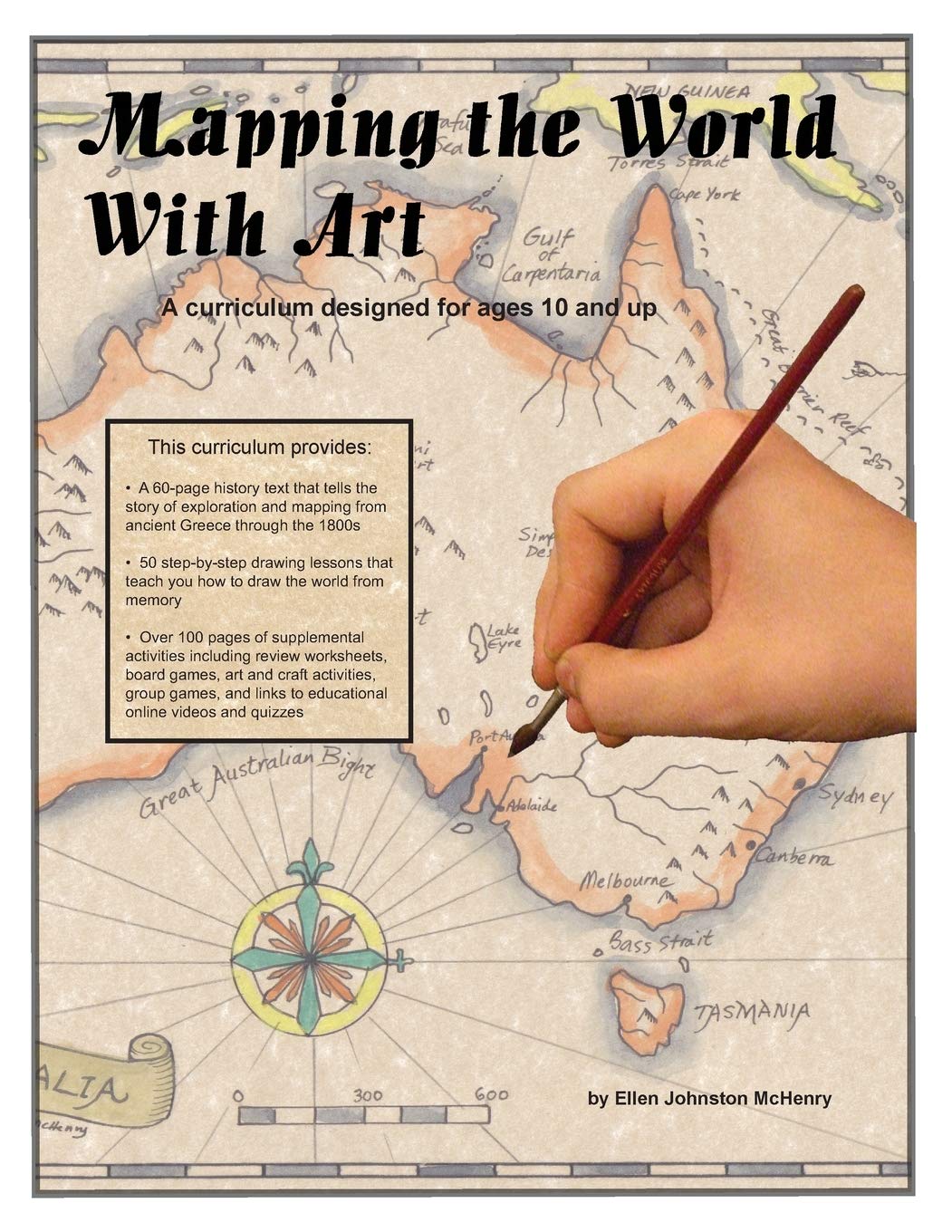
Mapping the World with Art is a blend of history, geography, and art that makes learning engaging and fun.

شحن
سريع

استرجاع
مجاني*

تغليف آمن

منتجات أصلية %100

الامتثال لمعيار PCI DSS

حاصل على شهادة ISO 27001




Note: Step Down Voltage Transformer required for using electronics products of أمريكا store (110-120). Recommended power converters اشتري الآن.


مايفيد
Artistic Cartography
Combines stunning artworks with detailed maps, offering a captivating visual experience that educates while inspiring creativity.
Cultural Insights
Explores diverse cultures through maps, allowing readers to appreciate global art styles and historical contexts in an engaging manner.
Interactive Learning
Encourages exploration and discussion, making it an ideal resource for teachers and art enthusiasts to foster curiosity and interaction.
تفاصيل المنتج
| Publisher | Ellen McHenry's Basement Workshop |
| Publication date | January 2, 2013 |
| Language | English |
| Print length | 320 pages |
| ISBN-10 | 0982537700 |
| ISBN-13 | 978-0982537701 |
| Item Weight | 1.65 pounds (750 grams) |
| Dimensions | 8.5 x 0.67 x 11 inches (21.6 x 1.7 x 27.9 cm) |
من يجب أن يشتري؟

-
Art Enthusiasts
Those who appreciate the intersection of cartography and creativity will find this book highly engaging and informative.
-
Educators
Teachers seeking innovative teaching resources on geography and art can use this book to enrich their curriculum.
-
Travel Planners
Individuals planning trips will find inspiration and meaningful connections through artistic interpretations of world maps.

-
Scientific Geographers
Professionals seeking rigorous scientific analyses and data may find the artistic focus overly simplistic for their needs.
وصف المنتج
Mapping the World with Art Paperback – January 2, 2013
هل لديك أي استفسار؟ تحدث معنا
أسئلة العملاء & الإجابات
-
سؤال:
What is 'Mapping the World with Art' about?
إجابه: 'Mapping the World with Art' is an exploration of how artistic expression can enhance our understanding of geography and place. The book combines vivid illustrations with educational content, illustrating how different cultures represent their environments through art. This book is perfect for art enthusiasts and educators looking to integrate visual learning into their geography lessons. It showcases a range of artistic styles and mediums, making it a valuable resource for anyone interested in the relationship between geography and art. -
سؤال:
Who is the author of 'Mapping the World with Art'?
إجابه: The author of 'Mapping the World with Art' is Joan N. M. LaBounty. LaBounty is known for her expertise in art and geography, and she skillfully combines these fields in this book. Her research focuses on how cultural identity is expressed through art, making her insights especially relevant to educators and students in both art and social studies. This background gives readers a unique perspective on how individuals and cultures relate to the world around them through artistic representation. -
سؤال:
Who is the target audience for this book?
إجابه: 'Mapping the World with Art' targets a wide audience, including students, educators, and art enthusiasts. It's particularly beneficial for teachers looking to incorporate creative methods into geography lessons. Additionally, parents can use this resource to help their children understand geographical concepts through engaging visuals. The captivating illustrations and insightful commentary also appeal to art lovers who appreciate the intersection of art and cultural studies, making it a versatile tool for various educational settings. -
سؤال:
What age group is 'Mapping the World with Art' suitable for?
إجابه: 'Mapping the World with Art' is suitable for a diverse age range, primarily aimed at students in middle and high school. However, its engaging visuals and accessible language make it a wonderful resource for younger learners as well, starting from elementary levels. Adults interested in art education or cultural studies will also find it beneficial. The book's ability to bridge gaps between age groups and educational levels allows it to be used in classrooms, libraries, and at home. -
سؤال:
Can 'Mapping the World with Art' be used in a classroom setting?
إجابه: Absolutely! 'Mapping the World with Art' is ideal for use in classroom settings. Teachers can utilize it as a supplementary resource for lessons in geography, art, and cultural studies. The book includes various artistic representations linked to geographical themes, which can spark meaningful discussions and encourage creative projects among students. By integrating this book into lesson plans, educators can promote critical thinking and enhance students' understanding of how art reflects cultural perspectives on geography. -
سؤال:
What topics are covered in the book?
إجابه: 'Mapping the World with Art' covers a variety of topics that merge art and geography, including cartography, cultural landscapes, and the role of art in expressing cultural identity. Each chapter focuses on different regions of the world, exploring the unique artistic practices and geographical contexts of those areas. This breadth of topics allows readers to gain a multifaceted understanding of how art interacts with geography, making it a comprehensive resource for anyone wanting to delve deeper into these disciplines. -
سؤال:
Is there a focus on specific cultures or regions in the book?
إجابه: Yes, 'Mapping the World with Art' emphasizes a range of cultures and regions throughout its pages. Each section highlights artistic traditions and geographical contexts from various parts of the world, enabling readers to discover the diversity of cultural expressions. The book delves into the artistry of indigenous cultures, contemporary movements, and how different geographical landscapes influence art creation. Understanding this relationship enriches readers' perspectives on cultural geography and the Bahrain art scene. -
سؤال:
Are there any interactive elements in 'Mapping the World with Art'?
إجابه: 'Mapping the World with Art' includes activities and discussion prompts that encourage readers to engage with the material actively. These interactive elements enhance comprehension and retention, allowing readers to reflect on their interpretations of the art and its geographical context. Whether used in a classroom or for self-study, these activities foster critical thinking and creative exploration, making the learning experience both enjoyable and educational. -
سؤال:
How can 'Mapping the World with Art' enrich my understanding of geography?
إجابه: 'Mapping the World with Art' enriches understanding of geography by illustrating how art reflects cultural identities and geographical realities. By examining various artistic expressions, readers can appreciate how local landscapes and cultural narratives shape artistic practices. This connection between art and geography deepens one's comprehension of spatial relationships and cultural significance, enabling a more nuanced view of the world. It’s an enlightening resource for promoting geographical awareness through a creative lens. -
سؤال:
Where can I buy 'Mapping the World with Art' in Bahrain?
إجابه: You can purchase 'Mapping the World with Art' on Ubuy in Bahrain. Ubuy offers a wide selection of books, including this title, and ensures easy access for readers interested in art and geography. By shopping on Ubuy, you can find further details about the book and enjoy a seamless purchasing experience tailored to your location.
Social Studies Editorial Review
لم يتم العثور على مراجعات تحريرية
مراجعات العملاء وتقييماتهم
1 تقييمات العملاء
-
5 نجمة
100%
-
4 نجمة
0%
-
3 نجمة
0%
-
2 نجمة
0%
-
1 نجمة
0%
أضف تقييم لهذا المنتج
شارك أفكارك مع عملاء آخرين
منصة موثوقة وثقة كاملة للمشتري

T
trusttaker
مشتري موثّق
“I loved it. That was my second order, and I am already thinking of placing a third order.”
16-Jul-26 · عبر Trustpilot
HA
Haitham
مشتري موثّق
“Trusted merchant”
11 July 2026 · عبر Trustpilot
MB
Maryam
مشتري موثّق
“The order arrived fast and in perfect condition”
2 June 2026 · عبر Trustpilot
MA
Mohammad
مشتري موثّق
“Excellent quality and very fast delivery, I really appreciate your service, when you work good I will appreciate that, I am very satisfied , thank you”
13 June 2026 · عبر Trustpilot
LA
Lulwa
مشتري موثّق
“I like the package arrived safely”
17 June 2026 · عبر Trustpilot
الخروج الآمن
شحن عالمي
إسترجاع سهل
منتجات أصلية
تاريخ سعر المنتج
معلومات مهمة
- القيود: بالنسبة للمنتجات التي يتم شحنها دولياً، يُرجى ملاحظة أن أي ضمان من الشركة المصنعة قد لا يكون صالحاً؛ قد لا تتوفر خيارات خدمة الشركة المصنعة؛ قد لا تكون أدلة المنتج والتعليمات وتحذيرات السلامة مكتوبة بلغة بلد المقصد؛ قد لا يتم تصميم المنتجات (والمواد المصاحبة لها) وفقاً لمعايير بلد الوجهة والمواصفات ومتطلبات الملصقات؛ وقد لا تتوافق المنتجات مع الجهد الكهربي المستخدم في بلد الوجهة والمعايير الكهربائية الأخرى (تتطلب استخدام محوّل كهربي أو جهاز تحويل إذا كان ذلك مناسباً). المستلم مسؤول عن ضمان إمكانية استيراد المنتج بشكل قانوني إلى بلد الوجهة. عند الطلب من يوباي أو الشركات التابعة لها، يكون المستلم هو المستورد المسجل ويجب أن يلتزم بجميع القوانين واللوائح الخاصة ببلد الوجهة.
- ليست كل المنتجات المدرجة على يوباي معروضة للبيع، لأن يوباي هو محرك بحث عالمي. المنتجات تخضع للوائح التصدير / التجارة.
BHD 17
اطلب الآن واحصل عليه حول الثلاثاء, سبتمبر 22
هذا المنتج غير ممنوع في بلدي. (الرجاء الضغط على الرابط أعلاه إذا لم يكن هذا المنتج ممنوعاً في بلدك ، لذلك سيقوم فريقنا بمراجعته والسماح به.)
كمية:
معاملة آمنة
نوفر لك مدفوعات مشفّرة، وحماية متكاملة للمشتري، مع الالتزام بمعايير PCI DSS وشهادة ISO 27001:2022 لضمان أعلى مستويات الأمان في كل عملية شراء.
أفضل شركائنا اللوجستيين
أسرع توصيل عبر الحدود
المميزات والفوائد
- Three books in one: history lessons, drawing lessons, and extra activities.
- Covers the evolution of cartography from ancient times to the late 1800s.
- Step-by-step drawing lessons enhance understanding of each historical lesson.
- Includes activities like crafts, games, and review worksheets for interactive learning.
- Designed for ages 10 and up, making it perfect for students and classrooms.
- Final project encourages students to draw a map of the world from memory.
ضمان Ubuy
تسوّق بثقة مع منتجات أصلية %100، ومدفوعات آمنة متوافقة مع معيار PCI DSS، وحماية بيانات معتمدة وفق ISO 27001، وشحن دولي سريع، وإرجاع مجاني*، وتغليف آمن لكل طلب.